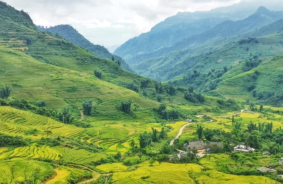
Y Ty sits in Lao Cai province at roughly 2,000 metres, near the point where Vietnam meets China. The area is inhabited mainly by the Ha Nhi people, whose distinctive low-profile earthen houses and hand-cut terraces have been shaped over generations by the altitude and the climate. The destination has remained quiet relative to Sapa, partly because of road conditions and border-zone formalities, and partly because it has not yet attracted the same volume of organised tourism.
Terraces and landscape
The terraces around Y Ty are concentrated in the lower-lying hamlets of Ngai Thau and A Lu, where fields step down steep hillsides in tightly curved bands. The visual character changes with the agricultural calendar: transplanted green shoots in early summer, ripening gold in September, and flooded mirror-like paddies in the planting season. Because the valley floors are narrow, the terraces climb unusually high on the slopes, giving a vertical drama that differs from the broader, more open terrace panoramas around Sapa.
The surrounding ridgelines are regularly covered by cloud banks that roll in from the valleys below, particularly in the cooler months. This phenomenon — locally called a cloud sea — has made the area a destination for photographers willing to wake before dawn and wait on a ridge for conditions to form.
Ha Nhi villages
The Ha Nhi are one of Vietnam's smaller recognised ethnic groups and Y Ty commune is among their main concentrations in the country. Their traditional houses are built from compacted earth, with thick walls and low rooflines that sit close to the ground, designed to retain heat at altitude and to resist the winds that come off the ridges in winter. Thatch or wooden shingles cover the roofs. From a distance, a Ha Nhi hamlet can be difficult to distinguish from the hillside it occupies.
Community life is organised around agricultural and ceremonial calendars that differ from those of the majority Kinh population. Visitors who arrive without a local introduction or guide will find that meaningful access to daily life is limited; the villages are not arranged for tourism and there are no formal visitor facilities within most hamlets.
Border-zone rules
Y Ty lies within Vietnam's border-zone administrative area adjacent to China. Regulations for this zone have historically required visitors — including foreign nationals — to carry identification at all times, and in some periods have required a separate border-zone permit in addition to a standard visa. The precise rules applicable to foreign visitors are unsettled and have changed more than once. Whether a permit is currently required, who issues it, and from where, should be confirmed with local authorities or a Lao Cai-based travel agency before departure. Arriving without the correct documentation has in the past resulted in visitors being turned back.
For general visa information, see Vietnam e-visa. Rules in border areas can change by administrative decree with little public notice, so the official source is the authority.
Getting there and away
Y Ty is reached from two main directions. The more common route runs from Sapa via the town of Bat Xat. The road is partially paved and partially dirt track depending on the section and the season; gradients are steep and corners are tight. A second approach comes up from Lao Cai city through Bat Xat district. Neither route is suitable for standard saloon cars after rain, and most visitors arrive by motorbike or 4WD vehicle.
Public transport to Y Ty is infrequent. Shared minibuses run from Bat Xat market on certain days, but schedules are irregular and not publicly documented in a reliable form. Renting a motorbike from Sapa or Lao Cai and riding independently is common; hiring a driver familiar with the road is the lower-risk option. The journey from Sapa takes several hours under good conditions.
There is no ATM in Y Ty. Bring sufficient cash. See Money, ATMs and cards for background on cash access in rural northern Vietnam.
When to go
September is widely considered the best month for the terraces: the rice ripens to gold before harvest, and the light at that elevation can be striking in the early morning. The window is narrow — harvest begins quickly once the grain is ready — and exact timing varies by year and altitude.
November through March brings cooler temperatures and the cloud-sea phenomenon that has drawn photographers in recent years. Cloud conditions are unpredictable; visiting for several nights improves the chances of witnessing a good display, but there is no guarantee.
The summer months bring heavy rain that degrades the road surface and limits visibility. For broader context on seasonal patterns across the northern highlands, see When to go: weather by region.
Why Y Ty stays quiet
Y Ty has not followed the trajectory of Sapa, which now receives large numbers of domestic and international visitors and has an extensive hotel and trekking infrastructure. Several factors account for the difference. The road is genuinely difficult, ruling out coach tourism and discouraging casual visitors. The border-zone permit question adds administrative friction. Accommodation in Y Ty is limited to basic homestays, with no guarantee of availability or standard. And the destination has not been absorbed into the major package-tour circuits that feed Sapa from Hanoi.
Whether this will remain the case is an open question. Infrastructure investment in the northwest has accelerated, and areas that were genuinely remote a decade ago are now accessible. Travellers seeking the quieter character Y Ty currently has should not assume that character is permanent. Nearby alternatives for those interested in terraces and ethnic minority culture include Bac Ha and Lai Chau.
Practical notes
Mobile signal in Y Ty is weak to absent in many parts of the commune. A local SIM may help on the approach roads but should not be relied on once off the main tracks. See SIM cards and eSIMs for options.
Accommodation is homestay-only in most of the commune; standards vary and advance booking through a Lao Cai or Sapa-based agency is advisable, particularly in September when demand peaks. There are no formal restaurants; meals are typically provided by the homestay.
The terrain and road conditions mean that a mechanical problem or a fall on a motorbike is a serious matter at distance from medical facilities. See Safety and common scams for general guidance. Travel insurance covering remote-area medical evacuation is a reasonable precaution.
월별 기후
장기 평균값이며 예보가 아닙니다. 기준 기간: 2015–2024. 출처: ERA5 reanalysis (Copernicus) via the Open-Meteo archive API.
Show the numbers
| 월 | 최고 기온 °C | 최저 기온(°C) | 강수량(mm) | 강수일수 | Humidity % |
|---|---|---|---|---|---|
| January | 13.6 | 7.0 | 147 | 17 | 87 |
| February | 15.0 | 8.3 | 102 | 15 | 83 |
| March | 19.3 | 11.6 | 163 | 18 | 81 |
| April | 21.4 | 13.8 | 218 | 19 | 79 |
| May | 22.5 | 15.9 | 267 | 25 | 85 |
| June | 22.6 | 17.1 | 325 | 28 | 91 |
| July | 22.7 | 17.1 | 366 | 29 | 90 |
| August | 22.6 | 17.0 | 394 | 29 | 91 |
| September | 21.7 | 16.1 | 246 | 25 | 89 |
| October | 19.3 | 13.6 | 184 | 22 | 89 |
| November | 17.4 | 11.3 | 89 | 15 | 86 |
| December | 13.8 | 7.7 | 101 | 14 | 87 |
Where it is
Also known as / see also
주변
참조 페이지
출처 목록
- ERA5 climate normals — Copernicus / Open-Meteo (CC BY 4.0) 접근됨 30 August 2026
Supports: monthly temperature and rainfall normals, and elevation - Vietnam National Authority of Tourism — VNAT 접근됨 29 August 2026
Supports: the rules and definitions on this page - Y Tý — Wikipedia (Vietnamese) (CC BY-SA 4.0) 접근됨 29 August 2026
Supports: carried over from the first build
Current 마지막 확인: 29 August 2026. Rules, fares and prices change — check the official source before acting on anything here. Report a mistake.
Picture credits (1)
Kiếm Anh, CC BY-SA 4.0, Wikimedia Commons