The place itself has not changed, and this page continues to cover it.
National Assembly Resolution 202/2025/QH15 on the rearrangement of provincial-level administrative units
Administrative status
Sóc Trăng existed as a province-level administrative unit until 30 June 2025, when Vietnam's national reorganisation merged its 63 provincial-level units into 34. On 1 July 2025, Sóc Trăng was merged into the enlarged Cần Thơ province, which now governs the area. The district tier was abolished at the same time; the area moved directly to a two-tier province/commune system.
This administrative change affects how mail is addressed and how local government functions, but it does not alter the geography, communities, temples, waterways or cuisine of the area. References to "Sóc Trăng" in travel and cultural contexts remain valid and widely used.
Character and identity
Sóc Trăng is one of the most culturally layered parts of the Mekong Delta. Three communities have shaped it over centuries: ethnic Vietnamese, Khmer Krom (the indigenous Khmer of the southern delta), and Teochew-speaking Chinese who settled in significant numbers from the 17th century onward. The result is a landscape dotted with ornate Theravada Buddhist wats, Chinese assembly halls, and Vietnamese đình, often within a short distance of one another.
The Khmer presence is especially visible. Sóc Trăng is home to a larger proportion of Khmer Krom than most other parts of the delta, and their calendar of festivals, agricultural practices, and monastery architecture give the area a character noticeably different from provinces further north. The Óc Om Bóc festival, held on the full moon of the tenth lunar month, involves boat races on the Maspero River and is among the most significant Khmer cultural events in Vietnam.
Landscape and waterways
The terrain sits near sea level throughout, a flat alluvial plain crossed by distributaries of the Mekong and by the Maspero River (Sông Maspero), which runs through the main urban area. Mangrove forest lines parts of the coastline along the East Sea (South China Sea), and shrimp and crab aquaculture is extensive in coastal zones.
Notable natural features include Mỏ Ó bird sanctuary, where large flocks of storks, herons and cormorants roost in seasonally flooded cajuput forest, and the network of fruit orchards on river islands accessible by small ferry. Coconut palms and melaleuca (cajuput) trees are characteristic of the vegetation throughout the lowlands.
- The Maspero River is navigable by small boats and connects urban Sóc Trăng town with surrounding communes.
- Coastal areas support extensive brackish-water aquaculture alongside remaining mangrove patches.
- Cajuput forest in low-lying areas floods seasonally and provides bird habitat.
Temples and cultural sites
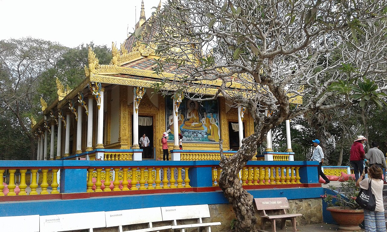
The most visited single site is Chùa Dơi (Bat Pagoda, formally Mahatup Pagoda), a Khmer Theravada wat in the main town where a large colony of fruit bats roosts in the temple grounds. The bats are protected by the monks and are considered sacred. The temple itself dates to the 17th century in its present location and retains traditional Khmer architectural detail in its gables and boundary walls.
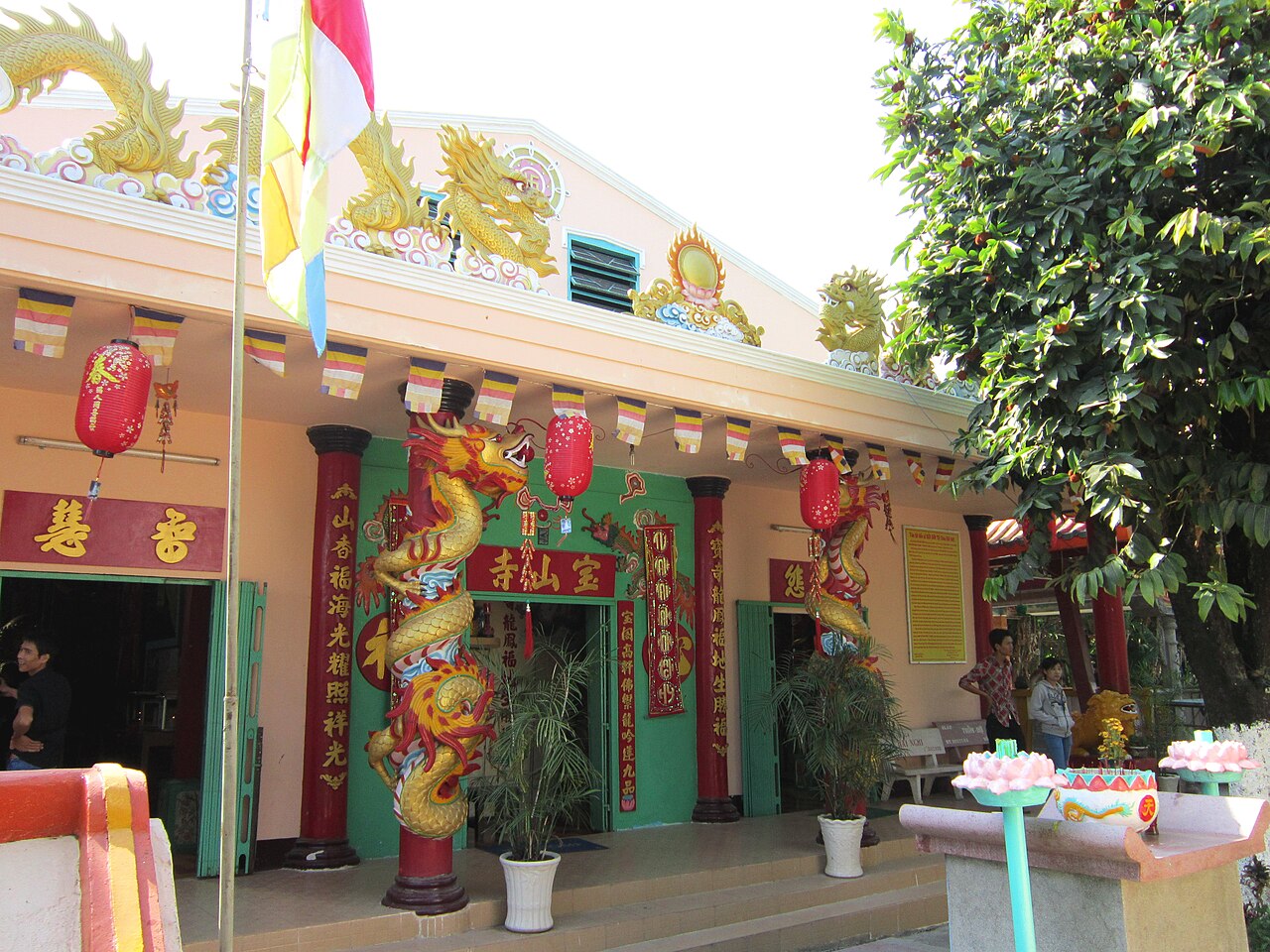
Chùa Đất Sét (Clay Pagoda) is a Vietnamese Buddhist temple remarkable for its interior, which is filled with thousands of handmade clay figures — Buddhas, bodhisattvas, mythological animals and candles — built up over decades by members of a single family. The largest clay candles are said to weigh several hundred kilograms each.
Chùa Kh'Leang, in the town centre, is among the oldest Khmer wats in the delta and is used as an active monastery. The Museum of Khmer Culture adjacent to it holds artefacts, textiles and documentation of Khmer Krom history in the region. Teochew Chinese heritage is represented by several clan association halls in the town's older commercial streets.
Food and produce
Sóc Trăng has a well-established regional food identity. Bánh pía is a flaky, layered pastry with Teochew origins, typically filled with mung bean paste, durian, or salted egg yolk; it is produced commercially in the town and sold throughout the delta and in Ho Chi Minh City. Bún nước lèo is a rice noodle soup with a fermented shrimp paste (mắm bò hóc) broth, pork, fish, and fresh herbs — considered one of the defining Khmer-influenced dishes of the delta.
Other locally notable foods include lạp xưởng Sóc Trăng (Sóc Trăng-style Chinese sausage), fresh crab and shrimp from coastal aquaculture, and a range of Khmer sticky rice preparations (xôi) prepared for temple festivals. The town market and surrounding street stalls are the primary venues for these foods; no single formal restaurant district dominates.
Climate and when to visit
The area has a classic southern Vietnamese monsoon pattern with two well-defined seasons. The dry season runs roughly from December through April: temperatures are at their highest in March and April, rainfall is minimal, and travel conditions are at their most predictable. January and February see the coolest nights of the year, though temperatures remain warm.
The wet season begins in May and peaks between September and October, when monthly rainfall is heaviest and flooding of low-lying areas is common. July, August, September and October all see substantial rain, and coastal and riverside areas can be temporarily inaccessible after heavy events. The Óc Om Bóc boat races fall in October or November (depending on the lunar calendar), meaning they occur at or just after the wettest part of the year; travel conditions around the event can be muddy but the festival draws large crowds regardless.
Prices vary by season, with accommodation and transport busier around major festivals and the December–January period.
Getting there and practical orientation
The main urban area — still commonly called Sóc Trăng town — sits roughly 230 km south of Ho Chi Minh City by road. The most common approach is by bus or private vehicle along National Highway 1 to Ngã Năm or via Cần Thơ city and then south. Cần Thơ city functions as the main regional transport hub, with the nearest commercial airport; travellers typically connect through Cần Thơ before continuing south by road.
Within the former province, movement between sites is almost entirely by road — motorbike, hired car, or local bus. Boat trips on the Maspero River and to river islands are available from town. There is no rail connection.
Common first-visit errors:
- Assuming that the July 2025 merger changed anything on the ground — Sóc Trăng town, its temples and its food are unchanged; only the administrative address is different.
- Visiting during the height of the wet season without accounting for potential road flooding in low-lying communes.
- Treating Chùa Dơi as a zoo rather than an active place of worship — the temple remains a functioning monastery and visitors are expected to dress and behave accordingly.
- Overlooking the town's Chinese heritage sites in favour of Khmer temples alone; the Teochew streetscape and food culture are a distinct and equally significant layer of local identity.
Khí hậu theo tháng
Số liệu trung bình dài hạn, không phải dự báo. Kỳ tham chiếu: 2015–2024. Nguồn: ERA5 reanalysis (Copernicus) via the Open-Meteo archive API.
Show the numbers
| Tháng | Nhiệt độ cao °C | Thấp °C | Lượng mưa (mm) | Ngày mưa | Humidity % |
|---|---|---|---|---|---|
| January | 29.9 | 22.8 | 38 | 6 | 77 |
| February | 31.2 | 23.0 | 11 | 2 | 73 |
| March | 33.0 | 24.0 | 20 | 4 | 72 |
| April | 33.7 | 25.0 | 77 | 12 | 74 |
| May | 32.7 | 25.5 | 215 | 26 | 81 |
| June | 31.0 | 24.8 | 260 | 29 | 86 |
| July | 30.1 | 24.5 | 318 | 30 | 87 |
| August | 30.4 | 24.6 | 283 | 30 | 86 |
| September | 30.2 | 24.2 | 342 | 29 | 87 |
| October | 30.1 | 23.9 | 356 | 28 | 88 |
| November | 29.9 | 23.9 | 205 | 21 | 86 |
| December | 29.4 | 23.2 | 94 | 12 | 81 |
Also known as / see also
Hiện là một phần của
Được tham chiếu bởi
Các nguồn
- ERA5 climate normals — Copernicus / Open-Meteo (CC BY 4.0) đã truy cập 30 August 2026
Supports: monthly temperature and rainfall normals, and elevation - Soc Trang (Q33272) — Wikidata (CC0 1.0) đã truy cập 30 August 2026
Supports: coordinates, area, population - Soc Trang — Wikipedia (CC BY-SA 4.0) đã truy cập 30 August 2026
Supports: background
Current Đã xác minh lần cuối: 31 August 2026. Rules, fares and prices change — check the official source before acting on anything here. Report a mistake.
Picture credits (4)
Chùa Đất Sét Sóc Trăng, Bùi Thụy Đào Nguyên, CC BY-SA 3.0, Wikimedia Commons · Đền thờ Bác, Bùi Thụy Đào Nguyên, CC BY-SA 3.0, Wikimedia Commons · Décortiquerie, Sóc Trăng, 1920s, Unknown, Public domain, Wikimedia Commons · Chánh điện chùa Dơi - Sóc Trăng, Phucphucphuc, CC BY-SA 4.0, Wikimedia Commons