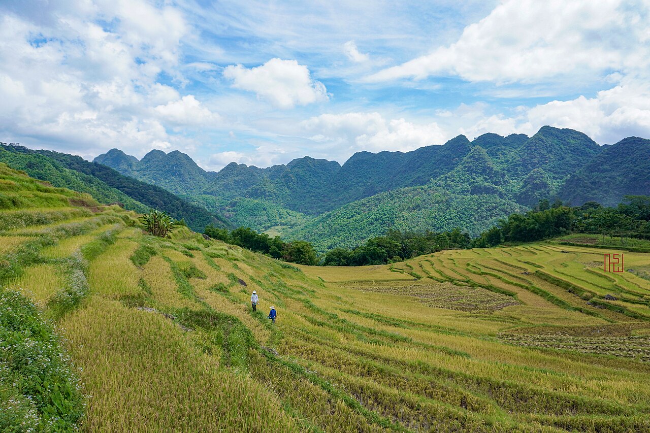
What Pu Luong is
Pu Luong Nature Reserve covers roughly 17,662 hectares of limestone and sandstone ridges in the western part of Thanh Hoa province, bordering Hoa Binh province to the north. Established in 1999, it protects one of the largest remaining areas of lowland limestone forest in northern Vietnam. The reserve sits in two main river valleys — the Cham and the Hieu — which open into broad, flat terraced floors unusually wide for mountain terrain. That width, combined with the elevation of surrounding peaks reaching above 1,700 metres, gives the landscape its signature quality: a sense of open space that most northern highland destinations lack. The resident population is predominantly White Thai and Muong, with smaller Kinh communities near the reserve's edges. Administratively the reserve falls within Thanh Hoa province under the post-2025 two-tier system.
Terraced rice and water wheels
The terraces of Pu Luong follow the valley floors and lower slopes, irrigated by a system of bamboo aqueducts fed from hillside streams. Traditional overshot water wheels — cọn in Thai — lift water from the Cham and Hieu rivers into the upper channels. Some wheels are several metres in diameter and operate year-round where water flow permits. They are functional rather than decorative, though they have become a widely recognised visual emblem of the reserve.
The rice calendar shapes the best periods to visit. Young green shoots appear in May and June; the harvest gold arrives in September and October. Both windows attract photographers and trekkers. The period from late July through August sees the heaviest rainfall — the climate data shows August as the wettest month by a significant margin — and trails can become slippery and rivers harder to ford. The cool dry months of December through February bring low temperatures overnight and morning mist, but the terraces are bare after harvest. See When to go: weather by region for broader context.
Trekking routes and villages
Trails connect a series of Thai stilt-house villages across both valleys. Commonly walked segments include routes between Ban Hieu and Ban Hang villages following the river, and longer crossings over the ridge between the Cham and Hieu valleys that pass through secondary forest and limestone outcrops. Walking times between villages range from under an hour to a full day depending on the route chosen. The paths are not formally waymarked in the style of European trails; local guides from the villages know the terrain and can navigate seasonal variations in conditions.
The reserve is less crowded than Mai Chau to the north or Sapa further north-west, though visitor numbers have grown substantially since around 2018. Most trekking is self-guided or guided informally through accommodation hosts. The terrain is moderate rather than demanding — there are no technical sections — but heat and humidity from April through September make physical exertion tiring. Carrying adequate water and informing accommodation of planned routes is standard practice.
Kho Muong cave
Kho Muong cave, located in the northern part of the reserve near the village of the same name, is one of the larger cave systems accessible to visitors in this area of Thanh Hoa. The cave has multiple chambers and a stream passage. It is not developed with lighting infrastructure in the manner of show caves such as those at Phong Nha, so visits require torches or headlamps and are typically arranged through local guides or the reserve management. The surrounding karst hillsides above the cave are forested and form part of the broader limestone ecosystem the reserve was created to protect. Access involves a walk from the nearest road; conditions on the approach path vary considerably by season given the high August–September rainfall in the area.
The lodge boom and what it has changed
From roughly 2017 onwards, a wave of eco-lodge and homestay construction transformed the accommodation landscape of Pu Luong. Several lodges built on elevated hillside positions offer views across the terraces; some are designed around traditional materials while others use contemporary architecture that sits conspicuously in the valley. The growth in capacity has made overnight stays straightforward to arrange independently, whereas previously homestay in villages was the primary option.
The change has brought money and employment to local communities but has also introduced pressures: increased vehicle traffic on narrow valley roads, demands on water supply during dry-season peaks and construction on slopes that had been farmed or forested. Whether the current model is sustainable is a subject of active discussion among tourism researchers and conservation organisations. The reserve's management capacity relative to visitor growth remains a point of concern in recent assessments. Visitors relying on cards should note that ATM access is limited in the valley; see Money, ATMs and cards.
Getting there
Pu Luong is approximately 130 kilometres from Hanoi and around 45 kilometres from Mai Chau. The most common approaches from Hanoi are by private car or motorbike via Highway 6 through Hoa Binh and then south into the reserve, or via Mai Chau and then south-east along provincial roads. Journey times from Hanoi by car are typically four to five hours depending on road conditions and the specific destination within the reserve; the valley roads narrow considerably inside the reserve boundary. Public bus connections exist to Quan Hoa town in the valley, from which onward travel requires local transport or arrangement with accommodation.
Combining Pu Luong with Mai Chau in a single trip is straightforward given the proximity. Ninh Binh and Cuc Phuong National Park lie to the east and can be included on a longer loop. Visitors arriving from abroad will need a valid entry document; see Vietnam e-visa for current requirements. Mobile connectivity improves but remains patchy in the deeper valleys; see SIM cards and eSIMs.
월별 기후
장기 평균값이며 예보가 아닙니다. 기준 기간: 2015–2024. 출처: ERA5 reanalysis (Copernicus) via the Open-Meteo archive API.
Show the numbers
| 월 | 최고 기온 °C | 최저 기온(°C) | 강수량(mm) | 강수일수 | Humidity % |
|---|---|---|---|---|---|
| January | 20.4 | 14.6 | 78 | 13 | 85 |
| February | 21.9 | 15.5 | 56 | 12 | 85 |
| March | 25.6 | 19.2 | 88 | 15 | 88 |
| April | 29.1 | 21.7 | 132 | 14 | 85 |
| May | 31.5 | 24.2 | 247 | 21 | 86 |
| June | 32.9 | 25.7 | 228 | 20 | 84 |
| July | 31.8 | 25.2 | 366 | 23 | 86 |
| August | 31.0 | 25.0 | 444 | 26 | 89 |
| September | 29.8 | 24.0 | 315 | 23 | 88 |
| October | 27.1 | 21.2 | 188 | 15 | 84 |
| November | 25.2 | 19.0 | 66 | 10 | 83 |
| December | 20.7 | 14.7 | 39 | 8 | 80 |
Practical notes
Where it is
Also known as / see also
주변
참조 페이지
출처 목록
- ERA5 climate normals — Copernicus / Open-Meteo (CC BY 4.0) 접근됨 30 August 2026
Supports: monthly temperature and rainfall normals, and elevation - Vietnam National Authority of Tourism — VNAT 접근됨 29 August 2026
Supports: the rules and definitions on this page - Pù Luông Nature Reserve — Wikipedia (CC BY-SA 4.0) 접근됨 31 August 2026
Supports: background - Khu bảo tồn thiên nhiên Pù Luông — Wikipedia (Vietnamese) (CC BY-SA 4.0) 접근됨 31 August 2026
Supports: background, Vietnamese edition
Current 마지막 확인: 31 August 2026. Rules, fares and prices change — check the official source before acting on anything here. Report a mistake.
Picture credits (1)
Ruộng bậc thang Pù Luông 1 - NKS, NKSTTSSHNVN, CC BY-SA 4.0, Wikimedia Commons