The place itself has not changed, and this page continues to cover it.
2025 constitutional amendment and Law on Organisation of Local Government establishing a two-tier local government
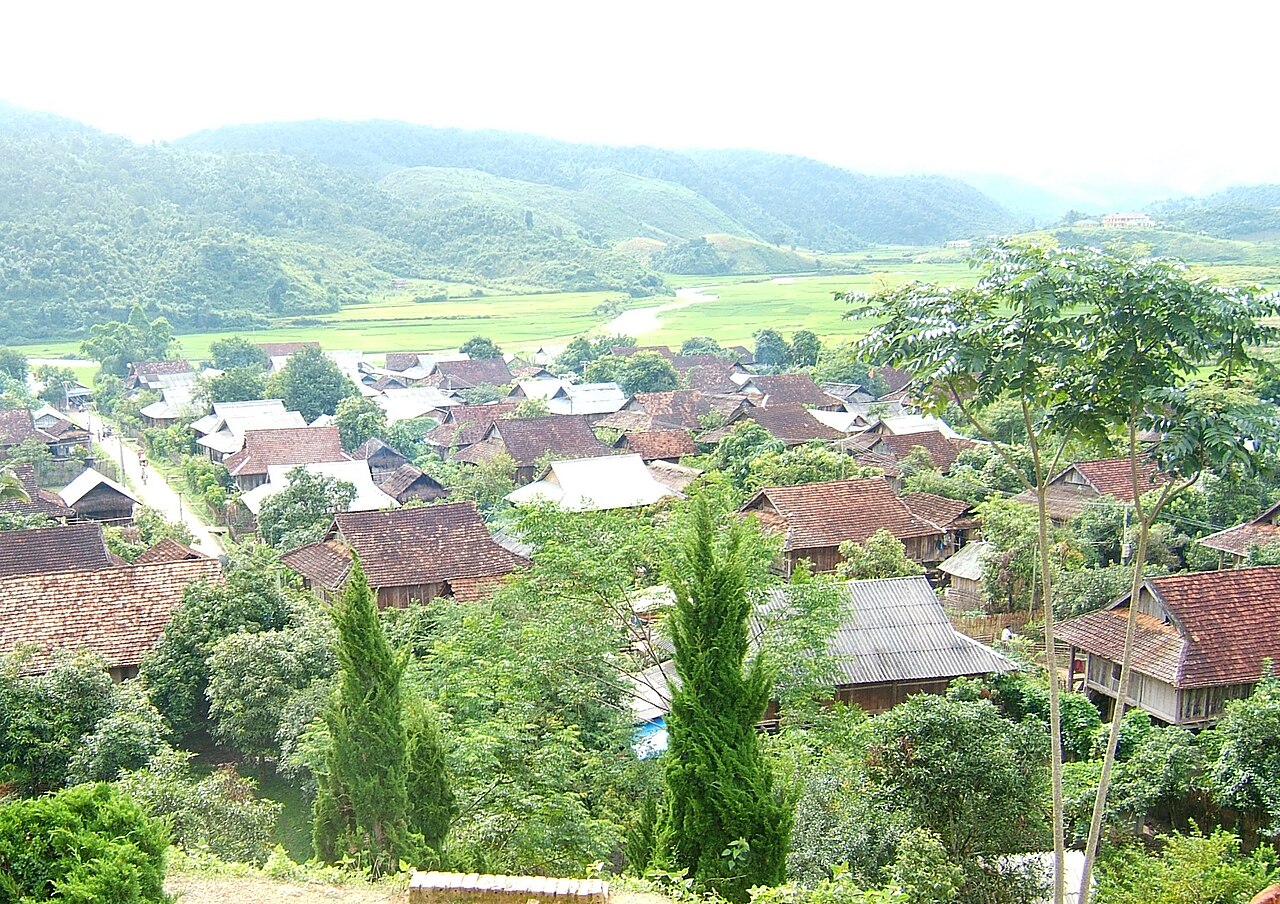
Moc Chau sits on a broad basalt plateau in Son La province, northwest Vietnam. The plateau is defined by its commercial tea gardens, dairy farms — unusual in the Vietnamese highlands — and two distinct blossom seasons that draw large numbers of domestic visitors. The landscape is agricultural in character: open hills worked in rows of tea and fruit trees, punctuated by the villages of Thai and H'Mong communities.
What Moc Chau is known for
The plateau's most distinctive feature is its tea cultivation. Rows of low-trimmed tea bushes cover the hillsides and can be walked among or viewed from the roadside; processing facilities operate in the area and locally produced tea is widely available.
Moc Chau also supports a notable dairy industry, a rarity in the Vietnamese highlands. Cattle graze on open pasture, and fresh and processed dairy products are sold throughout the plateau. This aspect of the local economy gives Moc Chau an agricultural character different from other highland destinations in the northwest.
The plateau's fruit orchards, particularly plum and peach, are the basis of its seasonal blossom tourism. Mustard flower — a yellow-flowering crop grown across the hillsides — adds a second distinct visual season in autumn.
Blossom seasons and when to go
Moc Chau has two principal blossom periods, each attracting significant visitor numbers from Hanoi and beyond.
- January to February: Plum and peach trees flower across the valleys, typically coinciding with the Lunar New Year period. White and pale pink blossoms appear against the green tea hills. This is the most celebrated season and also the most crowded.
- November: Mustard flowers cover the hillsides in yellow, creating a different but equally striking landscape. Temperatures are cool and skies are often clear at this time of year.
Outside these windows, Moc Chau receives far fewer visitors. The plateau is cooler than the lowlands year-round, and from December to February overnight temperatures can drop considerably. For a fuller picture of weather patterns across Vietnam's regions, see When to go: weather by region.
Dai Yem Waterfall and Pha Luong Peak
Dai Yem Waterfall (Thác Dải Yếm, meaning 'bib waterfall' or 'apron waterfall') is the most visited natural feature in the immediate area. It drops in a broad curtain into a pool below and is accessible on foot. The falls are most impressive during or after wet-season rains, when water volume is highest; in the dry months the flow reduces considerably.
Pha Luong is a peak on the border with Laos, rising to approximately 1,880 metres. It offers panoramic views across the plateau and into Laos on clear days. The ascent is physically demanding and is generally approached with a local guide; trail conditions and access arrangements are worth confirming locally before attempting the climb. The summit is notably cold in winter months.
Getting there: the QL6 from Hanoi
The standard road route from Hanoi follows National Highway 6 (QL6) westward through Phu Tho and Hoa Binh before climbing onto the plateau. The journey is approximately 200 km and the road is winding through the mountain sections; the drive takes considerably longer than the distance alone would suggest. The highway is paved throughout but requires careful driving, particularly on bends and in wet weather.
Sleeper buses and express coaches operate between Hanoi's My Dinh bus station and Moc Chau town. The fare and schedule depend on the operator and season. Motorbike is a common choice for domestic visitors who want flexibility on the route. There is no railway connection to Moc Chau.
Moc Chau is sometimes combined with Mai Chau — a valley settlement closer to Hanoi on the same highway — to make a longer northwest loop. Son La city lies further west along QL6 for those continuing deeper into the region.
Practical information
Moc Chau town is the main service hub on the plateau, with accommodation, restaurants and ATMs. Facilities become more limited away from the town centre. Coverage from local SIM cards is generally adequate in the town but can be patchy on higher ground or in remote valleys.
Weekend and holiday visits — especially during the blossom seasons — bring heavy traffic on QL6 and can put pressure on accommodation. Booking ahead is advisable for those periods. Outside peak seasons the plateau is considerably quieter.
Foreign visitors should ensure their visa or entry permission is current before travel; see Vietnam e-visa for current official requirements, noting that visa rules are subject to change by government decree. For currency and payment, see Money, ATMs and cards.
Nearby destinations
Moc Chau lies within Son La province following Vietnam's administrative consolidation of 1 July 2025, which merged the former Moc Chau district into the broader provincial structure. Whether Moc Chau warrants its own administrative designation within the new two-tier system is a question that remains unsettled.
Travellers in the broader northwest region may also consider Mai Chau, a valley known for White Thai villages and rice terraces, located back towards Hanoi on QL6. Pu Luong Nature Reserve lies to the southeast and offers a less-visited highland alternative. Perfume Pagoda is an option for those returning to Hanoi and willing to make a detour south of the highway.
Aya göre iklim
Uzun vadeli ortalamalar; tahmin değildir. Referans dönemi: 2015–2024. Kaynak: ERA5 reanalysis (Copernicus) via the Open-Meteo archive API.
Show the numbers
| Ay | En yüksek °C | En düşük °C | Yağış miktarı (mm) | Yağışlı gün sayısı | Humidity % |
|---|---|---|---|---|---|
| January | 18.2 | 10.6 | 59 | 11 | 86 |
| February | 20.4 | 11.6 | 38 | 8 | 83 |
| March | 24.6 | 15.5 | 76 | 15 | 84 |
| April | 27.2 | 17.9 | 112 | 17 | 80 |
| May | 28.6 | 20.4 | 208 | 22 | 82 |
| June | 28.9 | 21.7 | 190 | 21 | 83 |
| July | 28.1 | 21.3 | 277 | 24 | 86 |
| August | 27.3 | 20.9 | 367 | 26 | 89 |
| September | 25.9 | 19.8 | 261 | 23 | 89 |
| October | 23.2 | 17.1 | 166 | 17 | 86 |
| November | 21.8 | 14.8 | 52 | 10 | 85 |
| December | 17.8 | 10.5 | 35 | 8 | 84 |
Practical notes
Where it is
Also known as / see also
Yakın çevrede
Referans veren sayfalar
Kaynaklar
- ERA5 climate normals — Copernicus / Open-Meteo (CC BY 4.0) erişildi 30 August 2026
Supports: monthly temperature and rainfall normals, and elevation - Mộc Châu (Q6887452) — Wikidata (CC0 1.0) erişildi 30 August 2026
Supports: coordinates, area, population - Mộc Châu — Wikipedia (CC BY-SA 4.0) erişildi 30 August 2026
Supports: background
Current Son doğrulama: 29 August 2026. Rules, fares and prices change — check the official source before acting on anything here. Report a mistake.
Picture credits (6)
Nha san Moc Chau, Viethavvh at vi.wikipedia, Public domain, Wikimedia Commons · November 2024, Binh Chau - Phuoc Buu nature reserve, along South of central road, Syced, CC0, Wikimedia Commons · November 2024, Binh Chau - Phuoc Buu nature reserve, along South of central road 12, Syced, CC0, Wikimedia Commons · November 2024, Binh Chau - Phuoc Buu nature reserve, along South of central road 13, Syced, CC0, Wikimedia Commons · November 2024, Binh Chau - Phuoc Buu nature reserve, along South of central road 14, Syced, CC0, Wikimedia Commons · November 2024, Binh Chau - Phuoc Buu nature reserve, along South of central road 17, Syced, CC0, Wikimedia Commons